نظام ذكي لاكتشاف وتتبع الحفر في الطرق
Smart Lane Track Pothole Detection and Tracking System
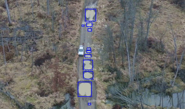
SmartLaneTrack is an AI-powered pothole detection and tracking system that analyzes aerial drone footage using a custom-trained YOLO12 model. It detects potholes in real time, assigns unique IDs, and visualizes results with bounding boxes to make road inspection faster, safer, and more efficient.
Project Overview
This project automates the detection and tracking of road potholes using aerial drone footage. By leveraging a custom-trained YOLO12 model, the system processes live or recorded video streams, identifies potholes, marks their locations, and tracks them across frames using persistent IDs. It is designed for large-scale infrastructure monitoring and maintenance planning.
Key Features
Drone-Based Input
- 🚁 Uses aerial drone footage for large-area road inspection.
- 🛣️ Efficient detection from top-down road views.
Custom YOLO12 Model
- 🧠 Trained specifically to detect potholes.
- ⚡ High accuracy in complex road environments.
Pothole Tracking with IDs
- 🆔 Assigns a unique ID to each detected pothole.
- 🔁 Tracks potholes consistently across frames.
Real-Time Performance
- ⏱️ Processes every third frame for speed optimization.
- ⚖️ Balanced performance between accuracy and efficiency.
Visual Output & Error Handling
- 🎨 Draws bounding boxes, labels, and pothole IDs.
- ⚠️ Gracefully exits if video input cannot be opened.
Technology Stack
- 🐍 Programming Language: Python
- 🎥 Computer Vision: OpenCV
- 🧠 Object Detection & Tracking: YOLO12 (Ultralytics)
- 📊 Data Processing: NumPy
- 🚁 Input Source: Drone Camera Footage
Use Cases
- 🏙️ Smart City Road Maintenance & monitoring.
- 🏛️ Government infrastructure audits.
- 📊 Web-based road health dashboards.
- 🚗 Autonomous vehicle navigation support.
Conclusion
SmartLaneTrack transforms drone footage into actionable insights for road infrastructure maintenance. By combining YOLO12-based detection, real-time tracking, and visual analytics, the system offers a scalable and efficient solution for governments and transport authorities to improve road safety, reduce maintenance costs, and prevent accidents.